Shaping the World – the power of belief.
 In my last blog I mentioned how in the middle ages religion turned back cartographic knowledge, so that people started to think the world was flat. Heck, maybe it was flat then, given the prevalence of the belief in Europe. Or maybe the Europeans lived on a flat earth while the rest of the world didn’t, but during that time religious maps placed a new world view in the forefront of European’s minds.
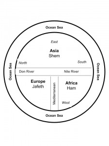
Some of the earliest maps, the ‘T-O maps’, from between 500 and 600 A.D. show a very different world than what we consider reality today. They were circular, disk-shaped maps (the O in T-O) that showed a circle of ocean around three continents that also made up a disk within the circle. At the top of the map was Asia that took up most of the top half of the circle. The bottom half was divided into Europe on the left and Africa on the right. Separating these three continents were the Mediterranean Sea (separating Europe and Africa), which was directly connected to the Don River and Nile River, which formed a horizontal margin across the middle of the map separating Asia from Europe and Africa. The confluence of the Mediterranean and the two rivers created the ‘T’ in the T-O map. The three continents were also each labeled and apportioned to the three sons of Noah, namely Shem, Japeth and Ham. The only further detail was the presence of Jerusalem at the heart of the world.
 Not a particularly helpful map if you needed to find your way from point A to point B, but what it did was point the way to a different way of viewing the world. Asia was paramount and so was the east, which was also placed at the top. The north sat on the left. Why and what did this mean?
It reflected the belief that paradise lay somewhere off to the east and thus Asia was important.
Other maps of that time period, placed a square of land floating in an Ocean Sea that was filled by the four great rivers of paradise. So, for a while at least, these often beautiful maps were of no help to anyone travelling or exploring. But that wasn’t their intention. These maps were created to shape minds and belief systems, rather than to reflect reality.
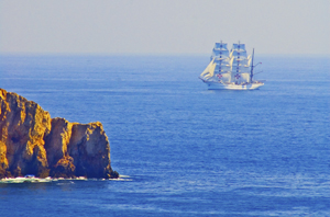
Of course people still went on voyages from point A to point B, and stories from adventures like the ‘mythical’ voyage of Saint Brendan of Ireland, fueled additions to maps for many years. Saint Brendan believed (contrary to the T-O maps), that paradise was an island somewhere in the Atlantic and so he sailed away and returned with tales of great adventures and the discovering of an island of great beauty and fertility that came to be known as Saint Brendan’s Island. Given the way the island changed its placement on maps over the next 1200 years, clearly this was an island with an outboard motor, but as late as 1721, long after the Age of Exploration and the Renaissance had dawned, the Portuguese were still sending out expeditions to find Saint Brendan’s Island. They never did, and the paradise promised by Saint Brendan faded from the map.
But in my imagination, I wonder if the island really did exist — until someone decided to erase it from the map, sort of like an adult deciding a child is too old to beleive in Santa Claus. Maybe the island’s erasure was the point when Euopean’s grew up in the world. Or not…
Which, I suppose, points to the fact that the human spirit might hold to faith, but it also cannot be contained by the simple boundaries of a T-O map.


