Author: Karen Abrahamson

Writer, sojourner, weaver of tales
Myths, Latitude and the Financial Shape of the Earth
Myths, Latitude and the Financial Shape of the Earth

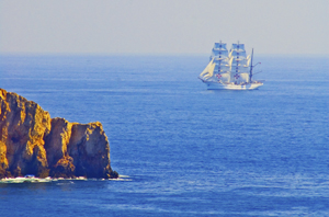
Despite the myths and rumors of a flat earth promulgated during the Middle Ages, most scientific minds over the centuries have known the world was a sphere. Clues to this came from the fact that boats sailing away disappeared gradually as if they sank from view, and did not simply diminish in size. The Greek philosopher and mathematician, Pythagoras, hypothesized that earth was a sphere based on the fact that the sphere is ‘the most perfect of forms’. If the sun and moon were such a shape, why not the earth? It was Pythagoras and other Greeks such as Plato and Aristotle who cemented the idea of a spherical earth in European culture.

So people knew the world was round, they just didn’t know the size of it, nor did fully understand its shape.

Estimating the size of the earth also harkens back to the Greeks. Both Aristotle and Archimedes had erroneous estimates of the earth’s circumference, but history hasn’t left any clues as to what those estimates were based on. The

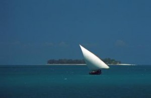
Going to market, Kashgar, China (1998) Photo (c) Karen Abrahamson

Chinese apparently sent two men to measure the earth and they walked it from north to south and east to west before coming up with the result of 134,000 kilometers (hopelessly in error).

The first (known) scientific measurement of the earth’s circumference came from an Egyptian named Eratosthenes during the time of the Ptolemy Kings. He knew of a water well in Southern Egypt where at noon on a certain day of the year the sun shone straight down to the bottom. He also had made observations that on the same day in Alexandria, at noon, there was still a shadow. He hypothesized that if he could measure the angle of the shadow on that day, he should be able to estimate the size of the earth. Using a vertical column he did just that, measuring the distance of the shadow from the base of the column. Then, with the length of the column, and the length of the shadow, he could calculate the third side of the triangle and determine the angel of the sun’s rays. Using basic geometry he was able to hypothesize that the earth was 46,000 kilometers in circumference – too large since we know today that the circumference is about 40,000 kilometers – but not too shabby for a man working with only a shadow and a column.

The debate about the actual size and shape of the earth continued over the centuries, with various other size estimates coming to prominence at different times. Contributing to the issue was the debate over the actual length of a degree, a debate that raged for centuries. This led to numerous ‘thinking men’ attempting to determine the length of a degree through methods ranging from counting the turns of a carriage wheel as it travelled between two points, to taking laborious chain measures of distance across the English countryside. It took debates of Newtonian and Cassini theories to help scientists realize that they were – in a word – wrong – about there being a definitive length of a degree.

You see, Newton formulated the theory of universal gravitation and that centrifugal force would mean that the earth could not be perfectly round. If he was right, due to the earth’s spin, the earth would be flattened at the poles and would bulge at the equator. Refuting this was the work of French scientist, Jacques Cassini, who had found that the length of a degree seemed to get slightly shorter at the poles compared to the equator. He theorized that this meant that the earth was shaped more like an egg, with poles drawn out and the equator flattened.
It took two expeditions in the 1700s, one to Peru and Ecuador, and other to Lapland, to settle the issue. While the trip to Peru dealt with altitude sickness, unfriendly Indians and disease, the expedition to Lapland had to race winters to take measurements. The team in Lapland completed their measurements after two years and found that the length of a degree was significantly longer in the north than a degree measured in France, thus proving that the earth was indeed compressed on the poles and bulging towards the equator. The poor Peruvian team spent nine years completing their mission, and confirming Newton’s theory, only to discover that their work was redundant.

But what they showed was that the length of a degree will depend on the latitude:

  • The east-west degree at the equator = 111.321 kilometers, however the circumference along a meridional circle is 67.2 kilometers shorter.
  • The north-south degree at the equator = 110.567 kilometers and the
  • The north south degree at the poles = 111.9 (or 1.4 km longer)

All of which may be where the phrase ‘giving someone some latitude’ comes from: What they do (and how far they go) will depend on where they’re standing.

Which could explain the disparity in approach the Germans and Greeks are espousing to deal with the Eurozone financial crisis. It’s all latitude.
A Prince, a Prophecy and a Legend

A Prince, a Prophecy and a Legend

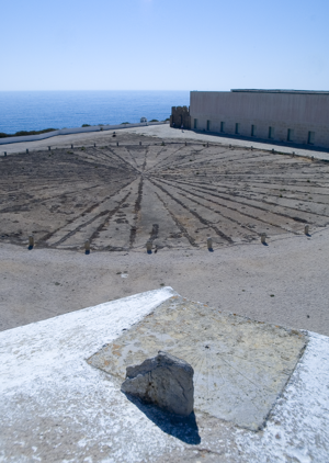
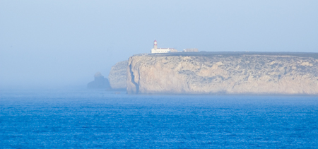
In southern Portugal, at a place called Sagre, I stood on red cliffs, high above an azure ocean and inhaled ocean wind and dust that had blown all the way from Africa. There, in an ancient fortress, laid out amid the scrub grass and rocky ground and seabird guano, laid a thirty foot, circular, roped off area that contained an old wind rose – a collection of ray lines that spread out to all points of a compass. This was the legendary home of Prince Henry the Navigator.

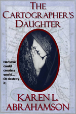
This was a few years back, when I had the good fortune to spend a month traveling around Portugal researching a prince for a book I was writing (The Cartographer’s Daughter). The prince I researched was none other than Prince Henry about whom the entire Portuguese psyche seems to revolve – or else he’s just a key tourist draw. You see everywhere you go in Portugal there are memorials to the old boy’s doings. In Porto there’s a museum that celebrates his birthplace. In Lisbon grand statues stand over the harbor and paintings of him fill the maritime museum. In Lagos another museum waits and elsewhere there are plaques and other statues. Why, you might ask? What did this man very few North Americans have heard of, do to deserve this kind of canonization?

I suppose the answer can be found in the wind rose.

Sagre windrose
The Sagre windrose has led to legends of a cartographer's school at Sagre. (2005) Photo (c) Karen Abrahamson

No, Henry didn’t invent the wind rose. Simply put, this foppish, spendthrift prince could be called the father of the Age of Exploration. Yes, there were many people that contributed to the dawn of new age of Europe, but good Prince Henry had something to prove and the full might of the Knights of Christ, the inheritors of the Knights Templar after they were disbanded, to help him do it. But I run ahead of myself. So who was Prince Henry?

The middle son of the Portuguese king, Henry was born under stars that astrologers proclaimed would devote Henry to ‘great and noble conquests and to uncovering secrets previously unknown to men’. Imbued with this sense of destiny, how could he help but be more than a middle son?

Henry grew up to be an ardent Christian and to become the head of the Knights of Christ. Along with that, came a driving hatred of the Moors and a determination to rid the European continent of them (they still held Granada). It also led to a dream of taking the Crusades across Gibraltar to Tangiers. His drive and his influence over his father led to one of the last European crusades—this one against the Moroccan trade city of Ceuta. The Portuguese won and held the city, but later, when they tried to advance they ended up routed from Tangiers and having to trade Henry’s younger brother for their freedom. This horrible blow some historians lay at Henry’s doorstep, but the loss of his brother was fuel to Henry’s fervor and he spent much of his life trying to revive the crusading fever amongst his cronies. It never came to be, but in the meantime Henry influenced a nation because he began to focus on maritime issues.

As a patron he began sending men on exploration along the African coast. Yes, he may have also been seeking a road to Christian Kings who could help him against the Moors, but his push and his financing, led to Gil Eannes becoming the first man to round Cape Bojador, which previously had been described as the end of the earth due to its difficult currents. With that passage, and with the improved sails and hull structures Henry’s money fostered, he ripped down a psychological barrier and the length and breadth of Africa beckoned. This led to a series of explorations sponsored by Prince Henry. He also fostered the collection of maps and sailors’portolan charts so that navigational information was shared and developed, before they became guarded national secrets.

The old Church at Sagre, (2005) Photograph (c) Karen L. Abrahamson

The interesting thing about Henry is that though we know so much about him, he still remains a man of mystery and legend. Records seem to show that he was an austere man who was deeply religious and sometimes given to mysticism at the same time as he liked to dress in foppish clothes and lavishly over spend the wealth of his estate holdings. He was also a man of learning who funded universities and financed astrologers and physicists and cartographers. But as I stood in Sagre by that wind rose I was struck by the rugged beauty that must have inspired him – that is until I went into the site’s visitor’s centre and they advised me that this fortress in Sagre was never a cartography school, though he did make his home here.

And the wind rose?

Henry’s involvement is just the stuff of legend.

Seeking Prestor John: We’re All Looking for Rescue

Seeking Prestor John: We’re All Looking for Rescue

Last week I talked about the legend of paradise contained in Saint Brendan’s Island and how that legend persisted through 1200 years of exploration. Explorers and Kings were looking for safety, and a way to return to the promised land. Perhaps, like a lot of us, they were looking for a return to a simpler time and hoped for someone to help in a time of dire need. This gave rise to another long-lasting legend – that of Prestor John.

Prestor (short for Presbyter) John was rumored to be a Christian King whose kingdom existed far to the east in Asia – or maybe it was Africa. That was sort of the trouble. The kingdom shifted and moved around the landscape, eluding the best explorers sent out by Popes and kings. But the myth of Prestor John held sway for many years with embellishments and details that included Prestor John’s Pedigree- right back to none other than King David.

Rumors of Prestor John’s kingdom began in 1150 – right about the middle of the Crusades and the Catholic Church’s intent to spread Christianity across the world. The legendary king was apparently a Christian King who had risen up and battled and beaten the Musselmen ( or the Moors, as the people of the Moslem east were then known) and become a powerful emperor. His presence became a symbol of hope in a time when the Christian west was at war with the ‘infidel’ in the holy land and the specter of infidel invasion disturbed the sleep of many western nobility and religious leaders.

The sudden hope and the belief in these rumors led to multiple dispatches of faithful retainers to find the mythic kingdom. Many never returned, but some traveled far to the east and actually met with the Mogul Khan, dispelling the myth that the Christian Kingdom existed in Asia.

But it also led to maps.

Yes, adventurers like Marco Polo gave detailed descriptions and maps of the places they had been (including the location of Prestor John’s Kingdom somewhere in China). More importantly, maps gained in value as European leaders sought to move people across the continent to the battles in the holy land. This led to the creation of pilgrim’s guidebooks, a type of map. The need to move such large numbers of men and equipment resulted in the enlisting of Venetian and Genoese merchants. The needs of such merchants for shipping ports, and the wealth of groups like the Knights Templar and the Knights Hospitaler led to the Holy Land becoming a mercantile centre for the movement of trade from Asia to Europe. The European hunger for spice and ‘things eastern’ involved Europeans in trade both in overland missions across the Asian continent and on coastal journeys along the southern Asian coast. Which led, by the 1300s to a renaissance of awareness of Asia and its wealth and the resulting creation of new maps.

But in the meantime it meant that Prestor John’s Kingdom shifted to the darkness of what was then called Abyssinia – a belief that still held sway as Europe began its shift towards the Age of Exploration. Figures central to the dawn of the exploration age still hoped that Africa might contain Prestor John’s Christians who could help against the Moors. Which makes me wonder if the enduring cold war of the 1950s, 60s and 70s might have influenced the rise of the SETI project. Perhaps we were looking for help ‘out there’ like the hope Prestor John provided to those long ago Christians.

Which begs the question: where are we going to be looking next?

Shaping the World – the power of belief.

Shaping the World – the power of belief.

In my last blog I mentioned how in the middle ages religion turned back cartographic knowledge, so that people started to think the world was flat. Heck, maybe it was flat then, given the prevalence of the belief in Europe. Or maybe the Europeans lived on a flat earth while the rest of the world didn’t, but during that time religious maps placed a new world view in the forefront of European’s minds.

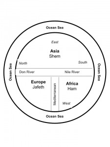
Some of the earliest maps, the ‘T-O maps’, from between 500 and 600 A.D. show a very different world than what we consider reality today. They were circular, disk-shaped maps (the O in T-O) that showed a circle of ocean around three continents that also made up a disk within the circle. At the top of the map was Asia that took up most of the top half of the circle. The bottom half was divided into Europe on the left and Africa on the right. Separating these three continents were the Mediterranean Sea (separating Europe and Africa), which was directly connected to the Don River and Nile River, which formed a horizontal margin across the middle of the map separating Asia from Europe and Africa. The confluence of the Mediterranean and the two rivers created the ‘T’ in the T-O map. The three continents were also each labeled and apportioned to the three sons of Noah, namely Shem, Japeth and Ham. The only further detail was the presence of Jerusalem at the heart of the world.

Not a particularly helpful map if you needed to find your way from point A to point B, but what it did was point the way to a different way of viewing the world. Asia was paramount and so was the east, which was also placed at the top. The north sat on the left. Why and what did this mean?

It reflected the belief that paradise lay somewhere off to the east and thus Asia was important.

Other maps of that time period, placed a square of land floating in an Ocean Sea that was filled by the four great rivers of paradise. So, for a while at least, these often beautiful maps were of no help to anyone travelling or exploring. But that wasn’t their intention. These maps were created to shape minds and belief systems, rather than to reflect reality.

Of course people still went on voyages from point A to point B, and  stories from adventures like the ‘mythical’ voyage of Saint Brendan of Ireland, fueled additions to maps for many years. Saint Brendan believed (contrary to the T-O maps), that paradise was an island somewhere in the Atlantic and so he sailed away and returned with tales of great adventures and the discovering of an island of great beauty and fertility that came to be known as Saint Brendan’s Island. Given the way the island changed its placement on maps over the next 1200 years, clearly this was an island with an outboard motor, but as late as 1721, long after the Age of Exploration  and the Renaissance had dawned, the Portuguese were still sending out expeditions to find Saint Brendan’s Island. They never did, and the paradise promised by Saint Brendan faded from the map.

But in my imagination, I wonder if the island really did exist — until someone decided to erase it from the map, sort of like an adult deciding a child is too old to beleive in Santa Claus. Maybe the island’s erasure was the point when Euopean’s grew up in the world. Or not…

Which, I suppose, points to the fact that the human spirit might hold to faith, but it also cannot be contained by the simple boundaries of  a T-O map.

The World is Flat: An ode to Columbus and all erroneous beliefs

The World is Flat: An ode to Columbus and all erroneous beliefs

The shapes of the world’s continents have changed ever since the time of the supercontinent, Pangaea. We’ve all seen the renditions of the continents shifting and South America unzipping from the edge of western Africa. Just looking at a map of the world it’s possible to see how the pieces of the earth fit together once. It may even be possible to conceive of how the continents might look millions of years in the future as the tectonic plates shift and move under and over each other. We think we know this now, but other ages of people thought they had the world’s shape figured out, too.

Contrary to popular belief, it didn’t take Columbus’s discovery of America to prove to the world’s thinkers that the earth wasn’t flat. Yes, in some parts of the world the belief was that the earth was a disc travelling on the back of a giant turtle, but back at the time of the Greeks and Egyptians and even before them, in China, great thinkers postulated that the world was round. They used logic and observation of the sun’s movement and shadows, as well as the way ships sink beneath the horizon to mathematically prove the earth’s general shape. What they didn’t know was the earth’s size. But that’s another story. They did, however, also theorize that the southern part of the earth were too hot for any human to inhabit. Happily for our friends south of the equator, they were wrong.

It was the Middle Ages that led to the belief that the world was flat. Maps became conveyers of religious dogma, as opposed to a representation of world. I’ll talk on this later, but as the world moved out of the Middle Ages into the Age of Discovery, the debate began about the shape of the solar system and whether it was terra centric (the sun and moon and planets revolving around the earth) or sol centric (the earth and all the other planets revolving around the sun). At the same time as these debates raged, people also debated the shape of the world’s continents. The prevailing belief seemed to be that Asia not only extended far to the east, but that it then hooked down and around the Indian Ocean to connect with the as-yet-undiscovered Cape of Africa, leaving the Indian Ocean as a land-locked sea.

What’s most interesting, is how human beliefs shaped the world around us. Think of the generations who grew up with these various beliefs. To them, the world WAS flat or the Indian Ocean WAS landlocked, or we really DID rely on a turtle to hold the whole thing up. That strength of belief colored all the beliefs of the early exploration of the east coast of whatever it was that Columbus discovered. first they believed it was the east coast of Asia. Then they believed it was a thin rind of a place, like a reef, that they could sail through. The maps show this. They show the ill-fated North West Passage, too – something that may finally exist if global warming continues its work.

In all of these cases it was the strength of their generation’s belief in what they’d drawn on their maps that kept explorers coming back to what became known as the Americas – and dying – again and again. When other beliefs gradually overtook the old ones, we gradually learned that what Columbus had really discovered was two new continents. Those layers of beliefs gradually reshaped the maps and thus the world we live in, much as my Cartos characters can believe and draw a new world into existence .

Which makes me wonder about the power of beliefs even today, when those who believe in a flat earth and those who believe in a round earth still wear away at each other like tectonic plates. Is it possible for such disparate beliefs to live side by side, or do these people actually inhabit two separate worlds?

And Columbus? He might have ‘proved’ that the earth was round, but he went to his grave believing that what he’d found was the backdoor to Asia, thus demonstrating that even an icon like Columbus could be blinded by his map of the world.

Recent Fantasy

Available HERE,

$1.99

Available HERE,
$3.99

Available HERE $1.99


Recent Mystery


Available HERE
$4.99


Available HERE,

$4.99


Available HERE,

$4.99


Available HERE,
$4.99


Recent Romance

Available HERE, $2.99